Ljósá
Appearance
Ljósá | |
|---|---|
Village | |
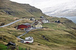
 Ljósá, looking south, with the village of Langasandur visible on the other side of Sundini (on Streymoy). | |
| Coordinates: 62°16′6″N 7°3′1″W / 62.26833°N 7.05028°W | |
| State | |
| Constituent country | |
| Island | Eysturoy |
| Municipality | Eiði |
| Founded | 1840 |
| Population (1 January 2006) | |
• Total | 36 |
| Time zone | GMT |
| • Summer (DST) | UTC+1 (EST) |
| Postal code | FO 466 |
| Climate | Cfc |
Ljósá (Template:Lang-da) is a village on the west coast of the Faroese island of Eysturoy in the Eiði municipality.
The 2005 population was 33. Its postal code is FO 466. It was founded in 1840.
External links
See also
Wikimedia Commons has media related to Ljósá.


