
Loma Prieta
| Loma Prieta | |
|---|---|
 Loma Prieta from the West | |
| Highest point | |
| Elevation | 3,790 ft (1,155 m) NAVD 88[1] |
| Prominence | 3,426 ft (1,044 m) NGVD 29[2] |
| Coordinates | 37°06′40″N 121°50′39″W / 37.111011844°N 121.844161333°W[1] |
| Naming | |
| English translation | Dark Hill |
| Language of name | Spanish |
| Geography | |
 Loma Prieta  Loma Prieta Loma Prieta (the United States) | |
| Parent range | Santa Cruz Mountains |
| Topo map | USGS Loma Prieta |
| Climbing | |
| Easiest route | Road |
Loma Prieta (from Spanish loma -hill, prieta -dark) is a 3,790 feet (1,160 m) Northern California mountain in the Santa Cruz Mountains.[3] The peak is on private property about 11 miles (18 km) west of Morgan Hill in Santa Clara County. The dirt road to the summit is gated, but the tower maintainers generally do not mind hikers.
From 1976 through 1990 amateur astronomer Donald Machholz set up his telescope an average of 120 times a year on the south slope of this mountain to search for comets. From this site he discovered three new comets that bear his name, including Periodic Comet Machholz 1 96P/Machholz on May 12, 1986.
The first official West Coast Messier marathon was conducted from this site in March 1979.
The epicenter of the 1989 Loma Prieta earthquake was near the mountain.
The mountain was the longtime site for the transmitter tower of San Jose television station KNTV (from 1955 to 2005). It moved its transmitter 83 kilometres (52 mi) northwest to San Bruno Mountain in September 2005, after it became the Bay Area's NBC affiliate.
Loma Prieta is the tallest peak in the Santa Cruz Mountains and thus it is common to see snow on the mountain during the winter.
-
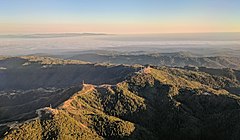 Loma Prieta (the peak just right of center) and other nearby peaks are festooned with television broadcast towers and other communication towers, serving the Santa Clara Valley. Fog-shrouded Monterey Bay and the Monterey peninsula are visible in the background in this late-afternoon approach to San José International Airport.

See also
References
- ^ a b "Loma Prieta Reset". NGS Data Sheet. National Geodetic Survey, National Oceanic and Atmospheric Administration, United States Department of Commerce. Retrieved 2009-08-07.
- ^ "Loma Prieta, California". Peakbagger.com. Retrieved 2009-08-07.
- ^ "Loma Prieta". Geographic Names Information System. United States Geological Survey, United States Department of the Interior.
