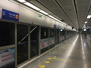
Lumphini MRT station
Appearance
Lumphini ลุมพินี | ||||||||||||||||
|---|---|---|---|---|---|---|---|---|---|---|---|---|---|---|---|---|
 | ||||||||||||||||
| General information | ||||||||||||||||
| Location | Sathon District, Bangkok, Thailand | |||||||||||||||
| Owned by | MRTA | |||||||||||||||
| Operated by | BMCL | |||||||||||||||
| Line(s) | MRT Blue Line and MRT Light Blue Line | |||||||||||||||
| Platforms | MRT Blue Line: 2 side platforms MRT Light Blue Line: 2 side platforms | |||||||||||||||
| Tracks | MRT Blue Line: 2 MRT Light Blue Line: 2 | |||||||||||||||
| Construction | ||||||||||||||||
| Structure type | MRT Blue Line: Underground MRT Light Blue Line: Elevated | |||||||||||||||
| Accessible | Yes | |||||||||||||||
| Other information | ||||||||||||||||
| Station code | LUM | |||||||||||||||
| History | ||||||||||||||||
| Opened | 3 July 2004 | |||||||||||||||
| Services | ||||||||||||||||
| ||||||||||||||||
Lumphini MRT Station (Template:Lang-th, code LUM) is a Bangkok Metro station. Located on Rama IV Road, near Witthayu Intersaction and Lumphini Park. Although station's name meaning to Lumphini Park, but Rama VI Monument that is the main sight of the park, is nearer to Si Lom MRT Station.
Station layout
| U3 Platform |
||
| Platform 1 | MRL (planned) towards Chong Nonsi | |
| Platform 2 | MRL (planned) towards Pracha Songkhro | |
| U2 Concourse |
Concourse | Exit, Ticket machines |
| G At-grade |
Street level | Bus stop, Lumphini Boxing Stage, Lumphini Park |
| B1 Concourse |
Concourse Level | Exits 1–2, and Ticket Vending Machines |
| B2 Platform |
Platform 2 | → MRT towards Bang Sue (Khlong Toei) → |
| Side platform, doors will open on the right | ||
| B4 Platform |
Platform 1 | ← MRT towards Hua Lamphong (Si Lom) |
| Side platform, doors will open on the left | ||
Station details
Lumphini is underground station, widths 20 metres, lengths 172 metres, and depths 26 metres. It uses split platform due to another half of Rama IV Road has Metropolitan Waterworks Authority's pipes. It uses symbol lotus and color green[1]
Bus connection
- Bangkok Mass Transit Authority
- Rama IV Road: Line 4 13 14 22 45 46 47 74 106 109 115 116 141 149 507 544
References
- ^ จุดเริ่มต้นของคนเดินทาง: ดำดินเดินทาง. คอลัมน์นายรอบรู้ นิตยสารสารคดี เดือนตุลาคม 2548
