
Mönckebergstraße

The Mönckebergstraße (locally also called Mö) is one of the main shopping streets in Hamburg, Germany.
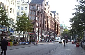
Mönckebergstraße is located in Hamburg-Altstadt, running some 800 m in east-west-direction between the Hauptbahnhof at Steintorwall and the Rathaus at Rathausmarkt. It is named after Johann Georg Mönckeberg, mayor of Hamburg in the 1890s and 1900s.
On the south side, Mönckebergstraße passes the churches of St. Petri and St. Jacobi. Halfway in between, Mönckebergstraße intersects with Spitalerstraße, another important shopping street. Notable attractions of this prominent four-way-fork-junction are the Mönckebergbrunnen (Mönckeberg-Fountain) and a former Bücherhalle building, now converted to a Burger King restaurant.
Many major retailers such as H&M, Kaufhof, Karstadt, Karstadt Sport, Peek & Cloppenburg, Saturn or Zara have a presence on Mönckebergstraße.[1] Many of the department stores have been converted from former kontor-houses.
-
 Grellhaus (left) at the intersection with Bergstraße
 -
 Barkhof (left) opposite Levantehaus (right)
 -
 Klöpperhaus (left) at the intersection with Lange Mühren


See also
References
- ^ "Mönckebergstraße". hamburg.de. Retrieved 7 October 2014.
External links
- Images of Mönckebergstraße on bilderbuch-hamburg.de Template:De icon
53°33′02″N 9°59′53″E / 53.55056°N 9.99806°E
This Hamburg location article is a stub. You can help Wikipedia by expanding it. |