Magic Island (Hawaii)
| Magic Island | |
|---|---|
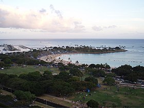
 Aerial view of Magic Island, featuring Ala Wai Yacht Harbor | |
 | |
| Location | Honolulu, Hawaii |
| Coordinates | 21°17′05″N 157°50′48″W / 21.284596°N 157.846595°W |
Magic Island is a small man-made peninsula in Honolulu, Hawaii, adjacent to Ala Moana Beach Park and the Ala Wai Yacht Harbor.[1] It was created in 1964 as the site of a resort complex, but was subsequently converted to a park.[2] The name was changed to "Aina Moana," but the new name is used infrequently.[3]
The park on Magic Island is a popular spot where people gather for picnics, frisbee, socializing, and occasional festival or drama performances. Because it was a preferred location among homeless squatters, overnight camping was recently banned in the park.
Each year, the Ala Moana Center puts on a fireworks show over Magic Island for the Fourth of July that draws numerous spectators to the surrounding parks. In conjunction with the show, the Ala Moana Center ropes off a portion of its parking lot for a Fourth of July concert featuring many local bands.
The park's hours are from sunrise to sunset daily.
Gallery
[edit]-
Magic Island during the day
-
Fireworks over Magic Island
-
Panorama from Magic Island
References
[edit]- ^ "Magic Island Lagoon | Hawaii Beach Safety". hawaiibeachsafety.com. Retrieved 2018-11-13.
- ^ Kido, H. (2014). HISTORIC AMERICAN LANDSCAPES SURVEY : ALA MOANA PARK (PDF). National Park Service. pp. 6–7.
- ^ Pukui, Mary Kawena (1974). Place names of Hawaii. Elbert, Samuel H. (Samuel Hoyt), 1907-1997,, Mookini, Esther T. (Rev. and enl. ed.). Honolulu: University Press of Hawaii. ISBN 082480208X. OCLC 1042464.
External links
[edit] Media related to Magic Island at Wikimedia Commons


