Jump to content

Mamoré Province

Coordinates: 13°10′01″S 64°40′01″W / 13.167°S 64.667°W / -13.167; -64.667
From Wikipedia, the free encyclopedia

This is an old revision of this page, as edited by Jllm06 (talk | contribs) at 19:01, 28 March 2014 (removed Category:Geography of Beni Department; added Category:Provinces of Beni Department using HotCat). The present address (URL) is a permanent link to this revision, which may differ significantly from the current revision.

Mamoré
Province
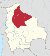
Map of Bolivia highlighting the province of José Ballivián.
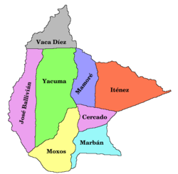
Provinces of the Beni Department
Country Bolivia
DepartamentBeni
SeatSan Joaquín
Settlements
Area
 • Total7,222 sq mi (18,706 km2)
Population
 (2006)[1]
 • Total13,695
 • Density1.9/sq mi (0.73/km2)
Time zoneUTC-4 (GMT -4)

Mamoré is a province in the Beni Department, Bolivia.

References

13°10′01″S 64°40′01″W / 13.167°S 64.667°W / -13.167; -64.667