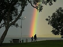
Maraetai
Maraetai is a town in the former Manukau City and the easternmost suburb of greater Auckland in New Zealand.

The closest town, Beachlands, lies approximately 4 km to the west. Its name is Māori meaning "meeting place by the sea". Maraetai was the original name for the smooth, calm tidal passage now known as Tamaki Strait, which is sheltered by Te Motu Arai-roa ("The Long Sheltering Island") now called Waiheke Island. The site of present-day Maraetai suburb was formerly the pā and kāinga (village) settlement known as Pohaturoa. In English, Maraetai means "meeting place by the sea". One of the better known functions of a marae is to facilitate hui (tribal gatherings).

Maraetai's residents do not use city mains water and instead must use water tanks and bore water.[1] Many residents prefer it to be kept this way to maintain the town's rural aspect. Maraetai's beaches are popular destinations for other Aucklanders and are often crowded in the summer months. The town is also home to the controversial pastor Brian Tamaki.
References
- ^ "Beachlands Options For Sustainable Development" (PDF). Manukau City Council. July 2008. p. 16.
36°53′S 175°02′E / 36.883°S 175.033°E

