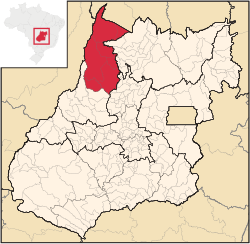
Microregion of São Miguel do Araguaia
São Miguel do Araguaia | |
|---|---|
 Location in Goias state | |
| Country | Brazil |
| State | Goiás |
| Mesoregion | Noroeste Goiano |
| Municipalities | 7 |
| Area | |
| • Total | 24,471.80 km2 (9,448.61 sq mi) |
| Population (2012) | |
| • Total | 77,067 |
| • Density | 3.1/km2 (8.2/sq mi) |
The São Miguel do Araguaia Microregion is a geographical region in northwest Goiás state, Brazil. The total population is 77,067 inhabitants (2012) in an area of 24,471.80 km².
Municipalities
The microregion consists of the following municipalities:[1]
See also
References
- ^ Instituto Brasileiro de Geografia e Estatística[permanent dead link], territorial division.
