
Milford Sound
.JPG)
Milford Sound, also known as Piopiotahi in Maori, is located in the south west of New Zealand's South Island. Although called a sound, it is more accurately classified as a fjord. Milford Sound, the most famous tourist site of New Zealand,[1] has also been called an eighth Wonder of the World by Rudyard Kipling.[2] It is situated within the Fiordland National Park which is in turn part of the Te Wahipounamu World Heritage site.
Milford Sound is named after Milford Haven in Wales, and the Cleddau River which flows into it is similarly named for its Welsh namesake. The Maori name for the sound, Piopiotahi, means first native thrush.
Geography
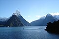
Milford Sound runs 15 kilometres inland from the Tasman Sea and is surrounded by sheer rock faces that rise 1200 metres or more on either side. Among the peaks are The Elephant at 1517 m (4977 ft), said to resemble an elephant's head,[3] and Lion Mountain, 1302 m (4271 ft), in the shape of a crouching lion.[4] Lush rain forests cling precariously to these cliffs, while seals, penguins, and dolphins frequent the waters.
Climate
With a mean annual rainfall of 6813 mm on 182 days a year,[5] a high level even for the West Coast, Milford Sound is known as the wettest place in New Zealand and one of the wettest in the world. Rainfall can reach 250 mm during a span of 24 hours.[6] The rainfall creates dozens of temporary waterfalls (as well as a number of major, more permanent ones) cascading down the cliff faces, some reaching a thousand meters in length. Smaller falls from such heights may never reach the bottom of the sound, drifting away in the wind.
Accumulated rainwater can at times cause portions of the rain forest to lose their grip on the sheer cliff faces, resulting in tree avalanches into the Sound. The regrowth of the rain forest after these avalanches can be seen in several locations along the Sound.
| Climate data for Milford Sound | |||||||||||||
|---|---|---|---|---|---|---|---|---|---|---|---|---|---|
| Month | Jan | Feb | Mar | Apr | May | Jun | Jul | Aug | Sep | Oct | Nov | Dec | Year |
| Source: NIWA Climate Data[7] | |||||||||||||
Tourism


Overview
The beauty of this landscape draws thousands of visitors each day, with over 550,000 in total per year.[8] This makes the Sound one of New Zealand's most visited tourist spots, and also the most famous New Zealand tourist destination,[1] even with its remote location and the long journey from the nearest population centres. Almost all tourists going to the sound also take one of the boat tours which usually last between 1-2 hours. They are offered by several companies, departing from the Milford Sound Visitors' Centre. There is also the option of extended overnight cruises on Milford Sound.
Hiking ('tramping', in New Zealand English) and canoeing are also possible. A small number of companies also provides overnight boat trips. There is otherwise only limited accommodation at the sound, and only a very small percentage of tourists stay more than the day.
An underwater tourist observatory found in one of the bays of the Sound provides viewing of black coral, usually only found in much deeper waters.[citation needed] A dark surface layer of fresh water, stained by tannins from the surrounding forest, allows the corals to grow close to the surface here.
Transport
By road, Milford Sound is 295 km from Queenstown and 279 km from Invercargill (about four hours drive),[9][10] with most of the tour buses to the Sound departing from Queenstown. Some tourists also arrive from the smaller tourism centre of Te Anau, 121 km away. There are also scenic flights by light aircraft and helicopter tours to and from Milford Sound Airport. The drive to Milford Sound itself passes through unspoiled mountain landscapes before entering the 1.2 km Homer Tunnel which emerges into rain-forest carpeted canyons that descend to the sound. The mountain road is very winding, and while of high standards, very prone to avalanches and closures during the winter half of the year.
The long distance to the Sound means that tourist operators from Queenstown all depart very early in the day, arriving back only late in the evening - this ensures that most tourists visit Milford Sound within a few hours around midday, leading to some congestion on the roads and at the tourist facilities during the main season. This peak time demand is also the reason for the large number of tour boats available at the Sound at the same time.[8]
Over the years, various options of short-cutting the distance to Milford Sound from Queenstown have been mooted, including a gondola route, a new tunnel from Queenstown, or a monorail from near Lake Wakatipu to Te Anau Downs. All would reduce the current round trip duration (which has to travel via Te Anau), thus allowing tourism to be spread out over more of the day. While the Gondola is considered to be out of the running after the DOC refused it for environmental reasons, the two other options are aiming to start consenting processes in 2007.[8]
Milford Sound can also be reached on foot as the final destination of the several-day Milford Track.
Other aspects
On 8 February 2004 a spill of 13,000 litres of diesel fuel was discovered, resulting in a 2 kilometre oil spill which closed the sound for two days while intensive cleanup activities were completed. Apparently a hose was used to displace the fuel from the tanks of one of the tour vessels, and various government officials claimed it appeared to be an act of ecoterrorism motivated by rising numbers of tourists to the park,[11] though more details did not become known. The spill has been removed and damage to the park's wildlife appears to have been minimal.
Near Milford Sound are also locations used to film some of the scenes of the Argonath in The Lord of the Rings: The Fellowship of the Ring [12].
Gallery
-
 Milford Sound on a stormy day.
 -
 Milford Sound with waterfalls running.
 -
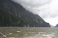
 Cliffs on the northern side on a wet and foggy day.
 -
 Milford Sound on a beautiful, clear winter day.
 -
 One of the southern side valleys of the sound.
 -
 View back into the sound from near the sea.


See also
References
- ^ a b Real Journeys rapt with Kiwi Must-Do's - Scoop Independent News, Tuesday 13 February 2007
- ^ Milford Sound, South Island, New Zealand (from the National Geographic Photo Galleries. Retrieved 2007-10-20)
- ^ The Elephant (from the mitrepeak.com cruise website)
- ^ Lion Mountain (from the mitrepeak.com cruise website)
- ^ Otago Climate (from the Otago Regional Council website, retrieved 2006-12-26)
- ^ Year 2004 (pdf-format, from the New Zealand National Climate Summary, Retrieved 2006-12-26)
- ^ "Climate Data". NIWA.
{{cite web}}: Unknown parameter|accessmonthday=ignored (help); Unknown parameter|accessyear=ignored (|access-date=suggested) (help) - ^ a b c Over And Under: Linking Queenstown and Milford Sound - e.nz magazine, IPENZ, May/June 2007
- ^ "Driving travel times & distance calculator". AA. Retrieved 2007-11-03.
- ^ "Travel distance & driving times calculator". Aim Solutions. Retrieved 2007-11-03.
- ^ Police probe Milford diesel spill 'terrorism' - New Zealand Herald, Tuesday 10 February 2004
- ^ The Lord of the Rings Location: Milford Sound (from travel website jasons.com)
External links
- Fiordland Bottlenose Dolphins (blog and information about conservation projects)
- Milford Sound - Destination Fiordland (regional tourism organisation)
- Panoramic 360° video of Milford Sound (from worldinmotionvr.com, requires Quicktime)