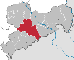
Mittelsachsen
Mittelsachsen | |
|---|---|
 | |
| Country | Germany |
| State | Saxony |
| Capital | Freiberg |
| Area | |
| • Total | 2,112 km2 (815 sq mi) |
| Population (31 December 2022)[1] | |
| • Total | 300,639 |
| • Density | 140/km2 (370/sq mi) |
| Time zone | UTC+01:00 (CET) |
| • Summer (DST) | UTC+02:00 (CEST) |
| Vehicle registration | FG, BED, DL, FLÖ, HC, MW, RL |
| Website | www |
Mittelsachsen ("Central Saxony") is a district (Kreis) in the Free State of Saxony, Germany.
History
The district was established by merging the former districts of Döbeln, Freiberg and Mittweida as part of the district reform of August 2008.
Geography
The district stretches from the Erzgebirge ("Ore Mountains") on the Czech Republic–Germany border to the plains between Leipzig and Dresden. The main rivers of the district are the Freiberger Mulde and Zschopau. The district borders (from the west and clockwise) the state Thuringia, the districts of Leipzig, Nordsachsen, Meißen, Sächsische Schweiz-Osterzgebirge, the Czech Republic, Erzgebirgskreis, the urban district Chemnitz, and the district of Zwickau.
Academic Education
The Landkreis is home to two universities, the TU Bergakademie in Freiberg (focused on Geo-science) and the University of Applied Sciences in Mittweida (MINT, Social, Media).[2]
Towns and municipalities
| Towns | Municipalities | |
|---|---|---|
References
External links
![]() Media related to Landkreis Mittelsachsen at Wikimedia Commons
Media related to Landkreis Mittelsachsen at Wikimedia Commons
- Official website (German)

