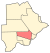
Mmopane
Appearance
Mmopane | |
|---|---|
| Country | |
| District | Kweneng District |
| Population (2011) | |
• Village | 14,655 |
| • Metro | Gaborone |
Mmopane is a village in the Kweneng District of Botswana. The village is located around 15 km from Gaborone, the capital of Botswana. The population was 3,512 in 2001 census and 14,655 at the 2011 census. It's now part of Gaborone agglomeration home to 421,907 inhabitants at the 2011 census. [1]
References
- ^ "Distribution of population by sex by villages and their associated localities: 2001 population and housing census". Archived from the original on 2007-11-24. Retrieved 2008-02-10.

