
Module talk:Location map/data/USA New York rivers
Map update for North American Datum[edit]
Created updated version of NYS rivers map using the CRS North American Datum "NAD27 Central New York" (EPSG:32016)
-
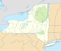 NAD27
NAD27 -
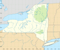 NAD27 with grid


@420Traveler: Any comments or concerns before I swap this new version for the existing one? - DutchTreat (talk) 12:34, 22 May 2022 (UTC)
- @DutchTreat: It looks really good, this is going to be so helpful for many articles. Its not important and doesn't matter to me if its added or not, But if it's not too much of a hassle could the last 3 fingerlakes have the creeks added to connect them to the other creeks. Otherwise, amazing job, I don't know how to thank you for all the hard work you've. -420Traveler (talk) 12:17, 23 May 2022 (UTC)
- @420Traveler: I will gladly add the three creeks connecting the Fingerlakes. Can you give me their names or other details like relation ID on OpenStreetMap? - DutchTreat (talk) 12:48, 23 May 2022 (UTC)
- @DutchTreat: Thank you so much, Here are the three creeks: Keuka Lake Outlet, Owasco River, Skaneateles Creek. I also think that the one other bigger finger lake (Otisco Lake) should be added if you dont mind:Otisco Lake, Ninemile Creek, Onondaga Lake/short Onondaga Outlet. Promise this will be all that's needed, dont mean to keep adding things. Then you can replace it. Thanks so much again -420Traveler (talk) 21:51, 23 May 2022 (UTC)
- @420Traveler: I will start to add these features. Expecting this will take me a few weeks. Having these specific references from the USGS NationalMap.gov helps guide me. - DutchTreat (talk) 12:19, 24 May 2022 (UTC)
- @420Traveler: Finished with all changes except the "Onondaga Lake Outlet". I'm using the OSM as the source. There is a relation 2321822 as multipolygon which is missing a centerline. This is not how all the others are handled. So it's left out for now. Please have a look and see if you have more changes in mind. - DutchTreat (talk) 19:42, 27 May 2022 (UTC)
- @420Traveler: updated module to use the latest NYS map with NAD27 projection. If you have any questions, ping me. - DutchTreat (talk) 11:24, 7 August 2022 (UTC)
- I have not made any corrections to the calculation of x/y positions. Therefore, there could be some slight miscalcuations around the edges since this is no longer an equirectangular view. The errors will be magnified for larger scales. For smaller maps, the errors will be only a few pixels. - DutchTreat (talk) 11:37, 7 August 2022 (UTC)
- @420Traveler: updated module to use the latest NYS map with NAD27 projection. If you have any questions, ping me. - DutchTreat (talk) 11:24, 7 August 2022 (UTC)
- @420Traveler: Finished with all changes except the "Onondaga Lake Outlet". I'm using the OSM as the source. There is a relation 2321822 as multipolygon which is missing a centerline. This is not how all the others are handled. So it's left out for now. Please have a look and see if you have more changes in mind. - DutchTreat (talk) 19:42, 27 May 2022 (UTC)
- @420Traveler: I will start to add these features. Expecting this will take me a few weeks. Having these specific references from the USGS NationalMap.gov helps guide me. - DutchTreat (talk) 12:19, 24 May 2022 (UTC)
- @DutchTreat: Thank you so much, Here are the three creeks: Keuka Lake Outlet, Owasco River, Skaneateles Creek. I also think that the one other bigger finger lake (Otisco Lake) should be added if you dont mind:Otisco Lake, Ninemile Creek, Onondaga Lake/short Onondaga Outlet. Promise this will be all that's needed, dont mean to keep adding things. Then you can replace it. Thanks so much again -420Traveler (talk) 21:51, 23 May 2022 (UTC)
- @420Traveler: I will gladly add the three creeks connecting the Fingerlakes. Can you give me their names or other details like relation ID on OpenStreetMap? - DutchTreat (talk) 12:48, 23 May 2022 (UTC)