Mokil Atoll
6°40′N 159°46′E / 6.667°N 159.767°E
Mwoakilloa (or Mokil previously named Wellington Island or Duperrey Island) is an inhabited atoll in the central Pacific Ocean. Geographically, it belongs to the Caroline Islands and is a district of the outlying islands of Pohnpei of the Federated States of Micronesia.
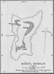
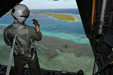
Mwoakilloa lies 153 kilometres east of Pohnpei and approximately 113 kilometres northwest of Pingelap. The almost-rectangular atoll is 4.5 kilometres long and 2.8 kilometres broad. The atoll consists of the three islands Uhrek, Kahlap (Capitol), and Mwandohn, forming a central lagoon of approximately 2 square kilometres in area. Only the northeast island Kahlap is inhabited, with the town facing the lagoon. The total area of all islands is approximately 1.24 square kilometres.
The population of Mwoakilloa decreased from 177 in 2000[1] to 147 in 2008. The inhabitants speak Mokilese — similar to the Pohnpeian language in the family of Micronesian languages.

The name "Wellington Island" comes from the vessel Marquis of Wellington, whose captain named the island after his vessel. The Marquis of Wellington was on her way to China, having transported 200 or so convicts to Port Jackson, Australia, from Britain.
References
- ^ Pohnpei Census 2000 (PDF)
External links
- Mokil on Oceandots at the Wayback Machine (archived December 23, 2010)
- Mokil in the German Colonial Lexicon (German)
- A map of the Mokil atoll


