Moosach (Munich)
Appearance
You can help expand this article with text translated from the corresponding article in German. (December 2011) Click [show] for important translation instructions.
|


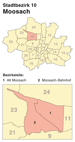
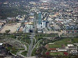
Moosach [ˈmoːsax] is a northwestern district of Munich, Bavaria, Germany.
It ist surrounded by: Feldmoching-Hasenbergl (north), Milbertshofen-Am Hart (east), Neuhausen-Nymphenburg (south), Pasing-Obermenzing (southwest) and Allach-Untermenzing (west).
It has a history of 4000 years of human settlement.[1]
Notable landmarks
- Abfallwirtschaftsbetrieb München
- Bahnhof München-Moosach
- Borstei
- Bundestagswahlkreis München-Nord
- Dachauer Straße
- Ehemaliges Pfarrhaus (Moosach)
- Georg-Brauchle-Ring
- Gymnasium München-Moosach
- Hochhaus Uptown München
- Knorr-Bremse
- Landshuter Allee
- Moosach (Isar)
- München Nord Rangierbahnhof
- Nederling
- Olympia-Einkaufszentrum
- Ortskern Moosach
- Schleißheimer Straße (Munich)
- Alte Pfarrkirche St. Martin (Moosach)
- Neue Pfarrkirche St. Martin (Moosach)
- St. Raphael (Munich)
- Städtisches Stadion an der Dantestraße
- Stimmkreis München-Moosach
- Studiosus Reisen
- U-Bahnhof Georg-Brauchle-Ring
- U-Bahnhof Moosacher St.-Martins-Platz
- U-Bahnhof Olympia-Einkaufszentrum
- U-Bahnhof Westfriedhof
- Westfriedhof (Munich)
48°11′N 11°31′E / 48.183°N 11.517°E
References
