
Mosken
| Lua error in Module:Location_map at line 526: Unable to find the specified location map definition: "Module:Location map/data/Norway - Mosken.png" does not exist. | |
| Geography | |
|---|---|
| Location | Nordland, Norway |
| Coordinates | 67°44′52″N 12°45′08″E / 67.74778°N 12.75222°E |
| Archipelago | Lofoten |
Mosken is a small uninhabited rocky island in the municipality of Værøy in Nordland county, Norway. The 1.5-square-kilometre (0.58 sq mi) island is located in the Lofoten archipelago about halfway between the islands of Værøy to the south and Moskenesøy to the north. The Moskenstraumen maelstrom—one of the most powerful in the world—is located on the north side of Mosken.[1][2] Historically, the island was used for grazing sheep in both the summer and the winter.[3]
Media gallery
-
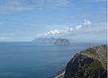 Mosken with Værøy in the background
 -
 Moskenstraumen with Mosken and Værøy in the background and Moskenesøy to the right
 -
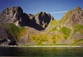 View of Mosken, seen from the sea
 -
 View of Mosken from Værøy, looking north


See also
References
- ^ Maelstrom, Encyclopædia Britannica on-line
- ^ Store norske leksikon. "Moskenesstraumen" (in Norwegian). Retrieved 2012-03-05.
- ^ "Værøy". GoNorway.no. Retrieved 2012-03-05.
This Nordland location article is a stub. You can help Wikipedia by expanding it. |