
Mount Hosmer (Iowa)
| Mount Hosmer | |
|---|---|
| Highest point | |
| Elevation | 1,040 ft (320 m) |
| Coordinates | 43°21′59″N 91°13′20″W / 43.36639°N 91.22222°W |
| Geography | |
| Location | Allamakee County, Iowa, United States |
| Climbing | |
| Easiest route | Road entrance |
Mount Hosmer is a bluff overlooking Lansing, Iowa. It is located directly adjacent to the Upper Mississippi River and offers a panoramic view of the river, including the Black Hawk Bridge. Mount Hosmer rises 450 feet above downtown Lansing.
Accessible from Lansing, Mount Hosmer Park is a popular destination for photographers. According to a plaque inside the park, Mount Hosmer is named for Harriet Hosmer, a sculptor, who won a footrace to the summit of the hill during a steamboat layover during the 1850s. [1]
-
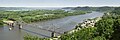 View from Mt. Hosmer
Notes
- ^ Sherwood, Dolly, ‘’Harriet Hosmer, American Sculptor: 1830-1908’’ University of Missouri Press, Columbia MO, 1991, p. 31
See also
- Pikes Peak, a similar park atop a bluff in Clayton County
This article about the geography of Allamakee County, Iowa is a stub. You can help Wikipedia by expanding it. |