
Mount Iyogatake
| Mount Iyogatake | |
|---|---|
| Iyogatake | |
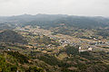
 View of southern slope of Mount Iyogatake, Minamibōsō, Chiba | |
| Highest point | |
| Elevation | 336.6 m (1,104 ft) |
| Coordinates | 35°6′26″N 139°54′50″E / 35.10722°N 139.91389°E |
| Naming | |
| Language of name | Japanese |
| Pronunciation | [ijoɡatake] |
| Geography | |
 Mount Iyogatake Chiba Prefecture, Honshu, Japan | |
| Parent range | Bōsō Hill Range |
| Climbing | |
| Easiest route | Hike |
Mount Iyogatake (伊予ヶ岳, Iyoga-take) is a mountain on the border of the city of Minamibōsō, Chiba Prefecture, Japan with an altitude of 336.6 m (1,104 ft). Mount Iyogatake is at the west of the Mineoka Mountain District of the Bōsō Hill Range, in close proximity to Mount Tomi.[1] The mountain takes its name from its resemblance to Mount Ishizuchi in Ehime Prefecture, formerly in Iyo Province.
Mount Iyogatake is one of the few mountains in the Bōsō Hill Range with steep rock cliff.[2] It can be easily climbed within 40 minutes. The entrance to the path of the mountain is between Heguri Elementary School and the Heguri Tenjin Shrine. Mount Iyogatake offers a clear view of the other mountains of the Bōsō Hill Range and Tokyo Bay,[3] and on clear days Mount Fuji and the Izu Islands are also visible.[4]
Mount Iyogatake and the Heguri Tenjin Shrine are associated with a legend of a tengu, a supernatural creature found in Japanese folklore.[5]
Transportation
The path to the peak of Mount Iyogatake is accessible by bus from the JR East Uchibō Line Iwai Station in Minamibōsō.
Gallery
-
 View of Mount Iyogatake
 -
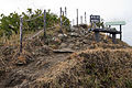 Summit of Mount Iyogatake
 -
 Summit of Mount Iyogatake


References
- ^ 伊予ヶ岳 Archived 2012-04-26 at the Wayback MachineTemplate:Ja icon
- ^ 南房総市富山 海と山Template:Ja icon
- ^ 伊予ケ岳(南房総市) Archived 2012-04-26 at the Wayback MachineTemplate:Ja icon
- ^ 伊予ヶ岳 いよがたけTemplate:Ja icon
- ^ 伊予ケ岳の天狗Template:Ja icon