Muchu Chhish
| Muchu Chhish | |
|---|---|
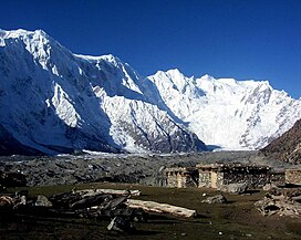
 Muchu Chhish is directly above the left side of the small structure as seen from the Batura Valley. The image has annotations visible by scrolling mouse over peaks at this link. | |
| Highest point | |
| Elevation | 7,453 m (24,452 ft)[1] |
| Prominence | 263 m (863 ft)[1] |
| Coordinates | 36°30′08″N 74°33′20″E / 36.50222°N 74.55556°E[1] |
| Geography | |
| Parent range | Karakoram |
| Climbing | |
| First ascent | Unclimbed |
| Easiest route | Technical |
Muchu Chhish (7,452 metres (24,449 ft)) (also known as Batura V) is a mountain in the Batura Muztagh sub-range of the Karakoram in Pakistan.[1] Located in a very remote and inaccessible region, only a handful of attempts have been made to reach the summit, none successfully. The most recent attempt was in 2014 when English mountaineer Pete Thompson turned back at the 6,000 m (20,000 ft) point.[2] Muchu Chhish is one of the tallest mountains on Earth that remain unclimbed and is possibly the tallest one of all that is not off limits due to religious or political prohibitions.[2] The peak has a modest prominence however, rising only 263 m (863 ft) above the nearest col or pass.[1] One of the longest glaciers outside the polar regions, Batura Glacier flanks Muchu Chhish to the north.
See also
References
- ^ a b c d e "Muchu Chhish, Pakistan". Peakbagger.com. Retrieved February 8, 2018.
- ^ a b "This place in Pakistan is one of the hardest places to reach on Earth". The Express Tribune. March 16, 2017. Retrieved February 8, 2018.

