
Muncy, Oklahoma
Muncy, Oklahoma | |
|---|---|
 Muncy, Oklahoma | |
| Coordinates: 36°49′12″N 101°45′46″W / 36.82000°N 101.76278°W | |
| Country | United States |
| State | Oklahoma |
| County | Texas |
| Elevation | 3,435 ft (1,047 m) |
| Time zone | UTC-6 (Central (CST)) |
| • Summer (DST) | UTC-5 (CDT) |
| Area code | 580 |
| GNIS feature ID | 1100654[1] |
Muncy (also called Muncey, Tracey or Tracy) is an unincorporated community in Texas County, Oklahoma, United States. Muncy is 18.2 miles (29.3 km) west-northwest of Guymon. The Panhandle Townsite Company founded Muncy in 1929, intending for the community to become a commercial and agricultural center for the region.[2] The Tracey Woodframe Grain Elevator in Muncy is listed on the National Register of Historic Places.[3]
References
- ^ "Muncy". Geographic Names Information System. United States Geological Survey, United States Department of the Interior.
- ^ "National Register of Historic Places Inventory - Nomination Form: Tracey Wood-frame Grain Elevator". Heritage Conservation and Recreation Service. Retrieved October 26, 2012.
- ^ "National Register Information System". National Register of Historic Places. National Park Service. July 9, 2010.
Municipalities and communities of Texas County, Oklahoma, United States | ||
|---|---|---|
| Cities | 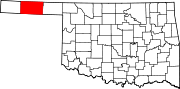 | |
| Towns | ||
| CDPs | ||
| Other communities | ||
This Oklahoma state location article is a stub. You can help Wikipedia by expanding it. |