Murgia, Álava
Appearance
Murgia | |
|---|---|
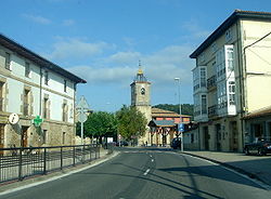
 View of the main street | |
| Coordinates: 42°57′25″N 2°49′15″W / 42.9569°N 2.8208°W | |
| Country | Spain |
| Autonomous community | Basque Country |
| Province | Álava |
| Comarca | Gorbeialdea |
| Municipality | Zuia |
| Area | |
| • Total | 5.78 km2 (2.23 sq mi) |
| Elevation | 618 m (2,028 ft) |
| Population (2021)[1] | |
| • Total | 1,105 |
| • Density | 190/km2 (500/sq mi) |
| Postal code | 01130 |
Murgia (Basque pronunciation: [murɣi.a], Spanish: Murguía [muɾˈɣi.a])[2] is a village and concejo located in the municipality of Zuia, in Álava province, Basque Country, Spain. It is the capital of the municipality as well as of the Cuadrilla de Gorbeialdea.
The main road in the village is Domingo de Sautu Street. The Goba River separates a neighborhood called The Cross from the centre of the village. To the north is Sarria, to the northeast Zarate, to the southeast Jugo, to the southwest Bitoriano, and to the west Ametzaga.[citation needed]
Demographics
[edit]| Year | Pop. | ±% p.a. |
|---|---|---|
| 2000 | 704 | — |
| 2001 | 789 | +12.07% |
| 2002 | 875 | +10.90% |
| 2003 | 1,016 | +16.11% |
| 2004 | 1,086 | +6.89% |
| 2005 | 1,113 | +2.49% |
| 2006 | 1,134 | +1.89% |
| 2007 | 1,169 | +3.09% |
| 2008 | 1,157 | −1.03% |
| 2009 | 1,181 | +2.07% |
| 2010 | 1,190 | +0.76% |
| 2011 | 1,201 | +0.92% |
| 2012 | 1,179 | −1.83% |
| 2013 | 1,186 | +0.59% |
| 2014 | 1,188 | +0.17% |
| 2015 | 1,158 | −2.53% |
| 2016 | 1,139 | −1.64% |
| 2017 | 1,117 | −1.93% |
| 2018 | 1,118 | +0.09% |
| 2019 | 1,099 | −1.70% |
| 2020 | 1,098 | −0.09% |
| 2021 | 1,105 | +0.64% |
| Source: [1][3] | ||
Notable people
[edit]- Mikel Landa (born 1989), cyclist[4]
- Unai Simón (born 1997), footballer[4]
References
[edit]- ^ a b "Nomenclátor: Núcleos". Entidades Locales de Álava (in Spanish). Diputación Foral de Álava. 1 January 2021. Retrieved 17 September 2022.
- ^ Salaberri Zaratiegi, Patxi (2015). Araba/Álava: Los nombres de nuestros pueblos (PDF) (in Spanish). Euskaltzaindia. p. 77. ISBN 978-84-944512-0-1. Retrieved 16 September 2022.
- ^ "Nomenclátor: Población del Padrón Continuo por Unidad Poblacional a 1 de enero 001100 MURGIA". INE. Retrieved 17 September 2022.
- ^ a b Rivas, Jon (4 July 2021). "El pueblo de Mikel Landa ya es el pueblo de Unai Simón" [Mikel Landa's village is now Unai Simón's village] (in Spanish). El País. Retrieved 9 January 2022.
External links
[edit] Media related to Murgia at Wikimedia Commons


