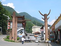
Muyu, Hubei
Muyu
木鱼镇 | |
|---|---|
 In Muyu's main street | |
| Coordinates: 31°28′14″N 110°23′39″E / 31.47056°N 110.39417°E | |
| Country | People's Republic of China |
| Province | Hubei |
| Forestry District | Shennongjia |
| Elevation | 1,216 m (3,990 ft) |
| Population (2010)[1] | |
| • Total | 9,089 |
| Time zone | UTC+8 (China Standard) |
Muyu (simplified Chinese: 木鱼; traditional Chinese: 木魚; pinyin: Mùyú; literally, "Wooden fish"; sometimes also 木鱼坪, Muyuping) is a town in Shennongjia Forestry District, in the west of Hubei province, People's Republic of China. Located on China National Highway 209, it is the main population and services center of the southern part of the district.
The town is stretched along the upper course of Xiang Stream (Xiang Xi) (or perhaps one of its tributaries), which flows from Shennongjia mountains southeast toward the Yangtze. The river valley is paralleled by China National Highway 209.
Serving as the natural "gateway" to Shennongjia National Nature Reserve[2] (the entry to which is at Yazikou Junction, some 10 to 15 kilometres (6.2 to 9.3 mi) north of Muyu), Muyu and its vicinity is the location of most of the hotels and tourist services in the southern part of Shennongjia. Regular minibus service connects it to Yichang and Maoping (Zigui County). There is also less-regular shuttle van service north, to Songbai town (the seat of government of Shennongjia District) and Shiyan; but the road north (beyond Yazikou Junction) is still "unimproved" (as of 2009), and, moreover, that part of Shennongjia is closed to foreigners.
Administrative Divisions
[edit]Residential communities:[3][4]
- Muyuping (木鱼坪社区), Honghuaping (红花坪社区), Xiangxiyuan (香溪源社区)
Villages:
- Honghuaping (红花坪村), Sanduihe (三堆河村), Laojunshan (老君山村), Chaoshuihe (潮水河村), Qingfeng (青峰村), Shennongtan (神农坛村), Muyu (木鱼村), Qingtian (青天村)
Climate
[edit]| Climate data for Muyu Town (1991–2018 normals) | |||||||||||||
|---|---|---|---|---|---|---|---|---|---|---|---|---|---|
| Month | Jan | Feb | Mar | Apr | May | Jun | Jul | Aug | Sep | Oct | Nov | Dec | Year |
| Mean daily maximum °C (°F) | 3.5 (38.3) |
5.8 (42.4) |
10.6 (51.1) |
16.7 (62.1) |
19.8 (67.6) |
22.8 (73.0) |
25.3 (77.5) |
24.7 (76.5) |
20.4 (68.7) |
15.6 (60.1) |
10.6 (51.1) |
5.5 (41.9) |
15.1 (59.2) |
| Daily mean °C (°F) | −0.9 (30.4) |
1.4 (34.5) |
5.6 (42.1) |
11.4 (52.5) |
15.1 (59.2) |
18.4 (65.1) |
21.1 (70.0) |
20.5 (68.9) |
16.3 (61.3) |
11.3 (52.3) |
6.1 (43.0) |
1.3 (34.3) |
10.6 (51.1) |
| Mean daily minimum °C (°F) | −5.2 (22.6) |
−3.0 (26.6) |
0.6 (33.1) |
6.1 (43.0) |
10.4 (50.7) |
14.1 (57.4) |
16.9 (62.4) |
16.2 (61.2) |
12.3 (54.1) |
7.1 (44.8) |
1.6 (34.9) |
−3.0 (26.6) |
6.2 (43.1) |
| Average precipitation mm (inches) | 16.8 (0.66) |
28.9 (1.14) |
56.7 (2.23) |
108.9 (4.29) |
156.2 (6.15) |
144.0 (5.67) |
205.0 (8.07) |
164.5 (6.48) |
136.3 (5.37) |
92.1 (3.63) |
51.6 (2.03) |
18.8 (0.74) |
1,179.8 (46.46) |
| Source: Baidu[5] | |||||||||||||
Gallery
[edit]-
In the evening in Muyu's main street
-
The town nestles in a mountain valley whose slopes are covered with forests and tea plantations
-
Harvesting tea leaves, on a slope right above the hotel area
-
A small farmstead on the hill slopes just outside the town
References
[edit]- ^ 神农架林区历史沿革 [Shennongjia Forestry District Historical Development] (in Simplified Chinese). XZQH.org. 6 August 2014. Retrieved 29 January 2019.
2010年第六次人口普查,神农架林区常住总人口76140人,其中:{...}木鱼镇9089人,{...}
- ^ Shennongjia, Home to the Wild Men? 2007-06-15. Retrieved 2009-10-04.
- ^ 木鱼镇 [Muyu Town] (in Simplified Chinese). XZQH.org. 1 August 2014. Retrieved 29 January 2019.
429021102:~001 121木鱼坪居委会 ~002 121红花坪居委会 ~200 122红花坪村 ~201 220三堆河村 ~202 220老君山村 ~203 220潮水河村 ~204 220青峰村 ~205 220神农坛村 ~206 220木鱼村 ~207 220青天村
- ^ 2020年统计用区划代码和城乡划分代码:木鱼镇 [2020 Statistical Area Numbers and Rural-Urban Area Numbers: Muyu Town] (in Simplified Chinese). National Bureau of Statistics of the People's Republic of China. 2020. Retrieved 8 January 2021.
统计用区划代码 城乡分类代码 名称 429021102001 121 木鱼坪居委会 429021102002 121 红花坪居委会 429021102003 121 香溪源社区居委会 429021102200 122 红花坪村委会 429021102201 220 三堆河村委会 429021102202 220 老君山村委会 429021102203 220 潮水河村委会 429021102204 220 青峰村委会 429021102205 220 神农坛村委会 429021102206 220 木鱼村委会 429021102207 220 青天村委会
- ^ "神农架林区木鱼镇历史气候数据(神农架林区)月尺度温度和降雨量(1961-2018年) - 百度文库". Baidu Library (in Simplified Chinese). Baidu. Retrieved 24 October 2024.


