Jump to content

Nam Ou

Coordinates: 20°03′N 102°13′E / 20.050°N 102.217°E / 20.050; 102.217
From Wikipedia, the free encyclopedia

This is an old revision of this page, as edited by InternetArchiveBot (talk | contribs) at 17:32, 11 February 2018 (Rescuing 1 sources and tagging 0 as dead. #IABot (v1.6.2)). The present address (URL) is a permanent link to this revision, which may differ significantly from the current revision.

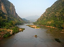
The Nam Ou (Laotian: ນ້ຳອູ [nâːm ùː], literally: "rice bowl river") is one of the most important rivers of Laos. It runs 448 km from Phongsaly Province to Luang Prabang Province[1]. Along with the Mekong, the Nam Ou is the only natural channel suitable for large-draft boat transportation. Near its confluence with the Mekong are the Pak Ou Caves, famous for their Buddha statues.

Dam Construckion at Nam Ou River
A ferryboat between Nong Kiau and Luang Prabang.
The 'Nam Ou' is an important transportation route in Laos.

20°03′N 102°13′E / 20.050°N 102.217°E / 20.050; 102.217