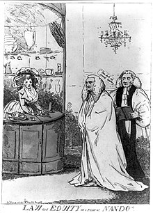
Nando's Coffee House

Nando's was a coffee house in Fleet Street in London. It was known to exist in 1696, being the subject of a conveyance, and was popular in the 18th century, especially with the legal profession in the nearby courts and chambers.
The name Nando is thought to be a short form of Ferdinando,[1] and its exact address is given variously as somewhere between 15 and 17 Fleet Street.[1][2] David Hughson wrote in 1807 that Nando's occupied the building at 15 Fleet Street[1] which was previously the Rainbow Coffee House.[3] However, property deeds in the Middle Temple Archive place the location of the coffee house at 14 Fleet Street.[4]
The venue was a favourite haunt of Edward Thurlow, who became Lord Chancellor, and he was satirised as being enamoured of the landlady's attractive daughter.[5]
Charles Lamb refers to Nando's in his essay "Detached Thoughts on Books and Reading", writing, "Newspapers always excite curiosity. No one ever lays one down without a feeling of disappointment. What an eternal time that gentleman in black, at Nando's, keeps the paper! I am sick of hearing the waiter bawling out incessantly, 'The Chronicle is in hand, Sir.'"[6]
See also
[edit]References
[edit]- ^ a b c Norman, Philip (1905). London Vanished & Vanishing. Macmillan.
- ^ Timbs, John (1872). Club Life of London.
- ^ Hughson, David (1807). London.
- ^ MT/4/1/12/5: 13-14 Fleet Street deeds, 1737-1926, 39 files. In the Middle Temple Archive.
- ^ Henry Benjamin Wheatley, Peter Cunningham (2011), London Past and Present: Its History, Associations, and Traditions, vol. 2, Cambridge University Press, pp. 571–572, ISBN 9781108028073
- ^ Lamb, Charles (1949). Brown, John Mason (ed.). The Portable Charles Lamb. New York: Viking. p. 442.
