
Nardin, Oklahoma
Nardin, Oklahoma | |
|---|---|
| Country | United States |
| State | Oklahoma |
| County | Kay |
| Area | |
• Total | 1.040 sq mi (2.69 km2) |
| • Land | 1.040 sq mi (2.69 km2) |
| • Water | 0 sq mi (0 km2) |
| Elevation | 1,086 ft (331 m) |
| Population | |
• Total | 52 |
| • Density | 50/sq mi (19/km2) |
| Time zone | UTC-6 (Central (CST)) |
| • Summer (DST) | UTC-5 (CDT) |
| ZIP code | 74646[3] |
| Area code | 580 |
| GNIS feature ID | 1095748[4] |
Nardin is a census-designated place (CDP) and unincorporated community in Kay County, Oklahoma, United States. Its population was 52 as of the 2010 census.[2]
References
- ^ "US Gazetteer files: 2010, 2000, and 1990". United States Census Bureau. 2011-02-12. Retrieved 2011-04-23.
- ^ a b "American FactFinder". United States Census Bureau. Retrieved 2011-05-14.
- ^ United States Postal Service (2012). "USPS - Look Up a ZIP Code". Retrieved 2012-02-15.
- ^ "Nardin". Geographic Names Information System. United States Geological Survey, United States Department of the Interior.
Municipalities and communities of Kay County, Oklahoma, United States | ||
|---|---|---|
| Cities | 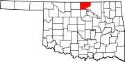 | |
| Towns | ||
| CDPs | ||
| Other communities | ||
| Ghost towns | ||
This Oklahoma state location article is a stub. You can help Wikipedia by expanding it. |