
Neudorf-Platendorf
Neudorf-Platendorf | |
|---|---|
 Coat of arms | |
Location of Neudorf-Platendorf  | |
 Neudorf-Platendorf  Neudorf-Platendorf | |
| Coordinates: 52°32′11″N 10°36′12″E / 52.53639°N 10.60333°E | |
| Country | Germany |
| State | Lower Saxony |
| District | Gifhorn |
| Municipality | Sassenburg |
| Elevation | 54 m (177 ft) |
| Population | |
| • Total | 2,760 |
| Time zone | UTC+01:00 (CET) |
| • Summer (DST) | UTC+02:00 (CEST) |
| Postal codes | 38524 |
| Dialling codes | 05378 |
Neudorf-Platendorf is a village in the municipality of Sassenburg in Gifhorn district in the German state of Lower Saxony.
Geography
Location
The village lies east of the River Ise and the state forest of Dragen. The Aller flows by to the south. To the north and east lies the Großes Moor.
The six kilometre long village street is the longest straight village road in Lower Saxony. One feature of the village are the bridges that link each property to the village street.
-
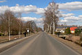 The main street
 -
 The school
 -
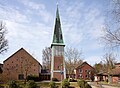 The Lutheran church

_IMG_5859.jpg)
_IMG_5851.jpg)
Literature
- Der Landkreis Gifhorn. Die Landkreise in Gifhorn, Bd. 26. Hrsg. von Niedersächsischen Landesverwaltungsamt, Bremen 1972, ISBN 3-87172-327-4.
External links
This Gifhorn district location article is a stub. You can help Wikipedia by expanding it. |