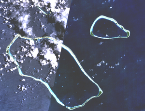
Nomoi Islands

The Nomoi Islands, also known as Mortlock Islands, are a group of three large atolls in the state of Chuuk, Federated States of Micronesia. They are located about 250 km to the southeast of Chuuk.[1]
Satawan, the southern atoll, is the largest. Both Etal,[2] the northern one, and Lukunor[3] in the northeast are much smaller. They are located between 9 and 6 km apart from each other.
They were discovered by the Spanish expedition of Álvaro de Saavedra in 1528.[4]
Captain James Mortlock rediscovered two sets of islands on 19 and 27 November 1795. Confusingly, both were later called Mortlock Islands.[5]
The Mortlock Islands in the Caroline Islands encompass the Nomoi islands and the Upper Mortlock Islands or Eastern Islands, which are Losap, Nama and Namoluk.
See also
References
- ^ Archived 2010-12-23 at the Wayback Machine
- ^ Archived 2010-12-23 at the Wayback Machine
- ^ Archived 2010-12-23 at the Wayback Machine
- ^ Riesenberg, Saul H., "Six Pacific Islands Discoveries", The American Neptune, Oct. 1974, p.249
- ^ The tale of the discovery of the two sets of “Mortlock Islands” Mariner’s Mirror, Journal of the Society for Nautical Research, May 2002
5°29′30″N 153°37′30″E / 5.49167°N 153.62500°E

