Norddalsfjord
Appearance
Norddal
Norddalsfjord | |
|---|---|
Village | |
 View of the village along the fjord | |
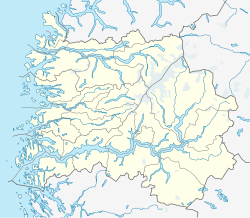
Location in Sogn og Fjordane county | |
| Coordinates: 61°38′34″N 05°22′42″E / 61.64278°N 5.37833°E | |
| Country | Norway |
| Region | Western Norway |
| County | Sogn og Fjordane |
| District | Sunnfjord |
| Municipality | Flora |
| Elevation | 25 m (82 ft) |
| Time zone | UTC+01:00 (CET) |
| • Summer (DST) | UTC+02:00 (CEST) |
| Post Code | 6900 Florø |
Norddal or Norddalsfjord is a village in Flora Municipality in Sogn og Fjordane county, Norway. The village lies along the Norddalsfjorden at the entrance to the Solheimsdalen valley. It sits at the mouth of the Norddalselva river on a small peninsula that sticks out into the fjord. The village lies along Norwegian County Road 544 about 25 kilometres (16 mi) east of the town of Florø, and about 4 kilometres (2.5 mi) northeast of the Norddalsfjord Bridge. Nordal Church is located in the small village, serving the northeastern part of the municipality.
References
- ^ "Norddal, Flora" (in Norwegian). yr.no. Retrieved 2013-11-08.


