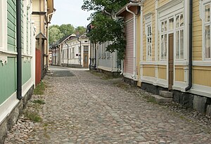
Old Rauma
| UNESCO World Heritage Site | |
|---|---|
 | |
| Criteria | Cultural: iv, v |
| Reference | 582 |
| Inscription | 1991 (15th Session) |
Old Rauma (Finnish: Vanha Rauma, Swedish: Gamla Raumo) is the wooden city centre of the town of Rauma, Finland. It is listed as a UNESCO World Heritage Site.
The area of Old Rauma is about 0.3 km², with approximately six hundred buildings (counting both proper houses and smaller buildings like sheds) and about 800 people living in the area. The town of Rauma expanded outside the Old Rauma proper only in the early 19th century. The oldest buildings date from the 18th century, as two fires of 1640 and 1682 destroyed the town. Most buildings are currently inhabited and owned by private individuals, although along the two main streets and around the town square they are mainly out side in business use.
Locations of special interest include the Kirsti house, which is a seaman's house from the 18th and 19th centuries, and the Marela house, which is a shipowner's house dating to the 18th century but with a 19th-century facade, both of which are currently museums. Other sights include the rare stone buildings of the Old Rauma: the Church of the Holy Cross, an old Franciscan monastery church from the 15th century with medieval paintings and the Old Town Hall from 1776. Another church in Rauma, the Church of the Holy Trinity, also from the 15th century, burned in the fire of 1640.
External links
![]() Media related to Old Rauma at Wikimedia Commons
Media related to Old Rauma at Wikimedia Commons
- Old Rauma as a VRML model
- Old Rauma information in English
