
Olst
Olst | |
|---|---|
 Coat of arms | |
| Coordinates: 52°20′16″N 6°6′39″E / 52.33778°N 6.11083°E | |
| Country | Netherlands |
| Province | Overijssel |
| Municipality | Olst-Wijhe |
| Population (2009) | 5,066 |
Olst is a village in the Dutch province of Overijssel, about 7 km north of Deventer. It is located in the municipality of Olst-Wijhe,
Until 2002, Olst was the seat of the municipality of the same name. The municipality was merged with that of Wijhe in 2001, keeping the name of the largest constituent part (Olst), until it was renamed Olst-Wijhe a year later.[1]
Transportation
- Railway station: Olst
-
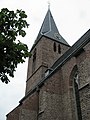 Protestant Church
 -
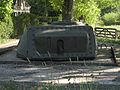 IJssellinie near Olst
 -
 River IJssel near Olst
 -
 de Haere near Olst


References
- ^ Ad van der Meer and Onno Boonstra, Repertorium van Nederlandse gemeenten, KNAW, 2011.
External links
- Template:Kuyper Map of the former municipality, around 1868.
52°20′N 6°07′E / 52.333°N 6.117°E
This Overijssel location article is a stub. You can help Wikipedia by expanding it. |