Orne (river)
| Orne | |
|---|---|
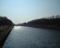
 The Orne in Caen | |
| Native name | L'Orne (f) Error {{native name checker}}: parameter value is malformed (help) |
| Location | |
| Country | France |
| Physical characteristics | |
| Source | |
| • location | Aunou-sur-Orne |
| • elevation | 240 m (790 ft) |
| Mouth | |
• location | English Channel |
• coordinates | 49°16′42″N 0°13′34″W / 49.27833°N 0.22611°W |
| Length | 170 km (110 mi) |
| Basin size | 2,932 km2 (1,132 sq mi) |
| Discharge | |
| • average | 27.5 m3/s (970 cu ft/s) |
The Orne (Ptolemeus Olina[citation needed]) is a river in Normandy, within northwestern France.[1] It discharges into the English Channel at the port of Ouistreham. Its source is in Aunou-sur-Orne, east of Sées. Its main tributaries are the Odon and the Rouvre.
The Orne flows through the following departments and towns:
- Orne (named after the river): Sées, Argentan
- Calvados: Thury-Harcourt, Caen, Ouistreham
Name
The name of the Orne in Normandy, which is referred to as the Olina by Ptolemy, is a homonym of Fluvius Olne, the Orne saosnoise in Sarthe, which Xavier Delamarre traces back to the Celtic olīnā (elbow).
Hydrology and water quality
The waters of the Orne are typically moderately turbid and brown in colour. pH levels of the Orne have been measured at 8.5[2] at the town of St. Andre sur Orne where summer water temperatures approximate 18 degrees Celsius. Electrical conductivity of the Orne has been measured at 30 micro-Siemens per centimeter.
See also
Notes
