
Otterburn Training Area
| Otterburn Training Area | |
|---|---|
| Otterburn | |
 The southern entrance to Otterburn MOD camp | |
 Otterburn Training Area Location within Northumberland | |
| Coordinates | 55°22′10″N 2°18′20″W / 55.36944°N 2.30556°W |
| Type | Training Area |
| Site information | |
| Owner | Ministry of Defence |
| Operator | |
| Site history | |
| Built | 1911 |
| Built for | War Office |
| In use | 1911-Present |
The Otterburn Army Training Estate (ATE) was established in 1911[1] and covers about 242 square kilometres (93 square miles) of the Southern Cheviots. It is owned by the Ministry of Defence (MoD), and used for training some 30,000 soldiers a year. Otterburn is the UK's largest firing range, and is in frequent use — artillery can be clearly heard from Lindisfarne to the north-east and Fontburn Reservoir in the south. The ranges are used by AS-90 Artillery and M270 Multiple Launch Rocket Systems and Otterburn is the only place in the UK where the MLRS can be fired, requiring an 11 mile long via 2 mile wide firing range.[1][2]
The training area accounts for 23% of the Northumberland National Park.[3]
Because of this, recreational use of the area is restricted, although it is possible for the public to use some parts of the estate subject to the relevant bylaws. The MoD publishes a booklet, Walks on Ministry of Defence Lands, which offers advice on this matter.[4]
Gallery
-
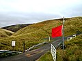 Otterburn Ranges. The road leading into the Ministry of Defence Ranges, and the red flag showing that the army are practising live firing there
 -
 Signpost for Otterburn Crossroads on the MOD ranges.
 -
 Entrance to the Otterburn Ranges near Holystone. Note the cattle grid.


References
- ^ a b Otterburn Public Information Leaflet pdf. hsmt.info
- ^ Nicholas Schoon (26 April 1997) Travel: Tanks for the wildlife. The Independent
- ^ Northumberland National Park – Otterburn Ranges. northumberlandnationalpark.org.uk
- ^ Walking guides on the Defence Estate, including Otterburn. Ministry of Defence
External links
![]() Media related to Otterburn Ranges at Wikimedia Commons
Media related to Otterburn Ranges at Wikimedia Commons