
Ozora, Missouri
Ozora, Missouri | |
|---|---|
 Ozora, Missouri, road sign | |
 Location of Ste. Genevieve County, Missouri | |
| Coordinates: 37°51′52″N 90°02′04″W / 37.86444°N 90.03444°W | |
| Country | United States |
| State | Missouri |
| County | Sainte Genevieve |
| Township | Beauvais[1] |
| Elevation | 538 ft (164[2] m) |
| Time zone | UTC-6 (Central (CST)) |
| • Summer (DST) | UTC-5 (CDT) |
| ZIP code | 63670 |
| Area code | 573 |
| FIPS code | 29-55892[3] |
| GNIS feature ID | 751469 [3] |
Ozora is an unincorporated community and census-designated place located in Beauvais Township in Sainte Genevieve County, Missouri. Ozora is located about eight miles south of Sainte Genevieve, Missouri."
Name
Ozora is located about a quarter of a mile from the earlier settlement of New Bremen, which had been settled by Germans and named after the port they had sailed from. In 1901 three names were submitted: New Bremen (because of the nearby community), Ida and Ozark. Since there was already an Ozark post office in Christian County, the name Ozora was coined from the word Ozark.[4]
Community
Ozora is home to the Sacred Heart Catholic Church and a Catholic elementary school.[5]
Demographics
2010 census
As of the census[6] of 2010, there were 183 people, made up of 100 males (54.64%) and 83 females (45.36%). The population density was 29.9 per square mile.[7] The racial makeup of the village was 97.81% White, 1.64% American Indian and Alaska native, and 0.55% from other races.[8]
Gallery
-
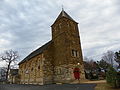 Sacred Heart Roman Catholic Church

References
- ^ Histopolis.com http://www.histopolis.com/Place/US/MO/Sainte_Genevieve_County/Ozora
- ^ Cartographic.info http://cartographic.info/usa/map.php?id=751469
- ^ a b Roadsidethoughts.com http://www.roadsidethoughts.com/mo/ozora-misc.htm
- ^ State Historical Society of Missouri: Ste. Genevieve County http://shs.umsystem.edu/manuscripts/ramsay/ramsay_sainte_genevieve.html
- ^ Visit Ste. Genevieve.com http://visitstegen.com/attractions/religious.html
- ^ "American FactFinder". United States Census Bureau. Retrieved 2012-07-08.
- ^ Census Viewer http://censusviewer.com/city/MO/Ozora
- ^ U.S.Census.gov https://www.census.gov/prod/cen2010/cph-2-27.pdf
Municipalities and communities of Sainte Genevieve County, Missouri, United States | ||
|---|---|---|
| Cities |  | |
| Townships | ||
| CDPs | ||
| Other communities | ||
| Ghost towns | ||
| Footnotes | ‡This populated place also has portions in an adjacent county or counties | |