Pähl
Pähl | |
|---|---|
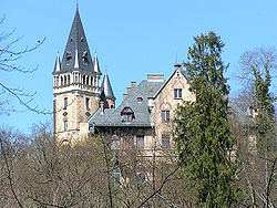
 Pähl Castle | |
Location of Pähl within Weilheim-Schongau district  | |
| Coordinates: 47°54′N 11°11′E / 47.900°N 11.183°E | |
| Country | Germany |
| State | Bavaria |
| Admin. region | Upper Bavaria |
| District | Weilheim-Schongau |
| Government | |
| • Mayor | Werner Grünbauer ([UBL]) |
| Area | |
| • Total | 32.04 km2 (12.37 sq mi) |
| Highest elevation | 760 m (2,490 ft) |
| Lowest elevation | 591 m (1,939 ft) |
| Population (2022-12-31)[1] | |
| • Total | 2,532 |
| • Density | 79/km2 (200/sq mi) |
| Time zone | UTC+01:00 (CET) |
| • Summer (DST) | UTC+02:00 (CEST) |
| Postal codes | 82396 |
| Dialling codes | 08808 |
| Vehicle registration | WM |
Pähl am Ammersee is a municipality in the Weilheim-Schongau district, in Bavaria, Germany. It is on the lake of Ammersee to the southwest of Munich.
Famous people
- Thomas Müller, footballer for Bayern Munich and Germany, grew up in the area.[2]
- Duchess Sophie Charlotte in Bavaria met Edgar Hanfstaengl there.
References
- ^ Genesis Online-Datenbank des Bayerischen Landesamtes für Statistik Tabelle 12411-003r Fortschreibung des Bevölkerungsstandes: Gemeinden, Stichtag (Einwohnerzahlen auf Grundlage des Zensus 2011) (Hilfe dazu).
- ^ "Dreamtime for Müller: "It's crazy"". bundesliga.de. Retrieved 13 July 2010.


