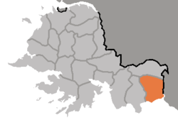
Paechon County

Coordinates: 37°58′47″N 126°18′15″E / 37.9797°N 126.3042°E / 37.9797; 126.3042
From Wikipedia, the free encyclopedia

This is an old revision of this page, as edited by 80.171.244.112 (talk) at 06:25, 19 November 2017. The present address (URL) is a permanent link to this revision, which may differ significantly from the current revision.

Paech'ŏn County
배천군
Korean transcription(s)
 • Hanja白川郡
 • McCune-ReischauerPaech'ŏn-gun
 • Revised RomanizationBaecheon-gun
Location of Paech'ŏn County
CountryNorth Korea
ProvinceSouth Hwanghae Province

Paech'ŏn County is a county in South Hwanghae province, North Korea.

Administrative divisions

Paech'ŏn county is divided into 1 ŭp (town), 1 rodongjagu (workers' district) and 26 ri (villages):

  • Paech'ŏn-ŭp
  • Pongryang-rodongjagu
  • Chŏngch'ol-li
  • Ch'angp'o-ri
  • Ch'ujŏng-ri
  • Hangjŏng-ri
  • Hŭngyŏl-li
  • Hwasal-li
  • Hwayang-ri
  • Ilgong-ri
  • Kangho-ri
  • Kŭmgong-ri
  • Kŭmsal-li
  • Kŭmsŏng-ri
  • Mulgil-li
  • Munsal-li
  • Obong-ri
  • Panghyŏl-li
  • Ponghwa-ri
  • Ryongdong-ri
  • Ryuch'ŏl-li
  • Sŏksal-li
  • Subong-ri
  • Suwŏl-li
  • Ulgil-li
  • Unsal-li
  • Wŏnsal-li
  • Yŏkku-ri

Transportation

Paech'ŏn county is served by the Paech'ŏn Line of the Korean State Railway.

37°58′47″N 126°18′15″E / 37.9797°N 126.3042°E / 37.9797; 126.3042