
Pedro Reinel

Pedro Reinel (? - c. 1542) was a Portuguese cartographer of the 16th century, author of one of the oldest signed Portuguese nautical chart (c. 1492). That is a portolan type of chart, covering western Europe and part of Africa, and already reflecting the explorations made by Diogo Cão in 1482-1485. With his son Jorge Reinel (c. 1502 - c. 1572), and the cartographer Lopo Homem, he participated in the construction of the well-known Miller Atlas (1519). His Atlantic Chart of c. 1504 is the earliest known nautical chart with a scale of latitudes, and the first to depict a wind rose with a clearly drawn fleur-de-lys.
-
 Pedro Reinel, (c.1485). Archives départementales de la Gironde, Bordeaux
 -
 Reinel compass rose
 -
 Pedro Reinel, North Atlantic (1535)
 -
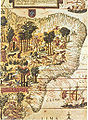 "Terra Brasilis", Miller Atlas, 1519, French National Library in Paris


