Peninsula Park
| Peninsula Park | |
|---|---|
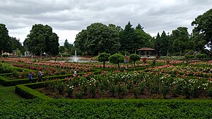
 The park's rose garden in 2017 | |
 | |
| Location | 700 N. Rosa Parks Way Portland, Oregon |
| Area | 16.27 acres (6.58 ha) |
| Created | 1909 |
| Operated by | Portland Parks & Recreation |
| Status | Open 5 a.m. to midnight daily |
Peninsula Park is a public park in the Piedmont neighborhood of Portland, Oregon.[1] The 16.27-acre (6.58 ha) park is located in the North Portland neighborhood and contains a outdoor swimming pool, community center, baseball fields, playgrounds, basketball courts, tennis courts, covered picnic areas, a historic gazebo and other amenities. In 2007, area residents started to propose a piece of public art be added to the park honoring Rosa Parks, as the park lies along Rosa Parks Way.[2]
Rose garden
Peninsula Park became the city's first public rose garden in 1909 when it was purchased for $60,000 with funds raised in a 1908 bond measure.[1] Designed by Emanuel L. Mische, the two-acre garden contains 5,700 roses featuring 75 varieties.[3] The official rose of Portland, named Mme. Caroline Testout, was cultivated at Peninsula Park. In 1913, the park was chosen as the location for an annual rose show, where it remained until Washington Park was selected as the location of the International Rose Test Garden in 1917.[1]
See also
References
- ^ a b c "Peninsula Park & Rose Garden". Portland Parks & Recreation. Retrieved July 16, 2011.
- ^ Parks, Casey (June 13, 2012). "North Portland residents work to bring public art piece honoring Rosa Parks to Peninsula Park". The Oregonian. Retrieved 15 June 2012.
- ^ Parks, Casey (June 13, 2012). "Peninsula Park's rose garden undergoing clean-up before 100th birthday". The Oregonian. Retrieved 15 June 2012.
External links
 Media related to Peninsula Park at Wikimedia Commons
