
Plum, Kentucky
Plum, Kentucky | |
|---|---|
 Plum, Kentucky | |
| Coordinates: 38°10′44″N 84°1′53″W / 38.17889°N 84.03139°W | |
| Country | United States |
| State | Kentucky |
| County | Bourbon |
| Elevation | 850 ft (260 m) |
| Time zone | UTC-5 (Eastern (EST)) |
| • Summer (DST) | UTC-4 (EDT) |
| GNIS feature ID | 508837[1] |
Plum is an unincorporated community in Bourbon County, Kentucky, United States. It was also known as Pinhook.
References
Municipalities and communities of Bourbon County, Kentucky, United States | ||
|---|---|---|
| Cities | 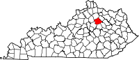 | |
| Unincorporated communities | ||
This Bourbon County, Kentucky state location article is a stub. You can help Wikipedia by expanding it. |