Prati

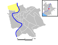
Prati is a historic neighbourhood (rione) of Rome in the centre of the city, bordering with the north of the Vatican State, within Rome's Municipio I. Its logo is the shape of Hadrian's mausoleum, in a blue color on a silver background. Although it technically belongs to the rione Borgo, the Hadrian's mausoleum (the modern Castel Sant'Angelo) is one of Prati's landmarks.

In administrative terms, Prati since 2013 belongs to I Municipio (the City historic Center) while before that year together with the rione of Borgo and the quartieri Trionfale and Della Vittoria (around Piazza Mazzini) was part of the XVII Municipio. Built as a public housing district to host civil servants coming from all over Italy, it now claims to be a bourgeois district. Prati is immediately to the north of the historical city centre of the City ("centro storico"), and to the east and northeast of the Vatican.
The busy Via Cola di Rienzo, one of the most famous streets in Rome, is consistently ranked among the most important shopping streets in the city.
Churches
- San Gioacchino in Prati
- Sacro Cuore del Suffragio
- Santa Maria del Rosario in Prati
- Beata Vergine Maria del Carmine
- Chapel of Santa Maria Assunta

Public buildings
- Court of Cassation, Italy's highest court

