Puchheim
Appearance
Puchheim | |
|---|---|
 Saint Joseph Church | |
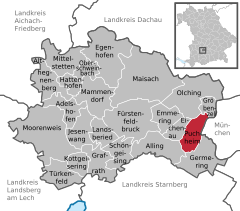
Location of Puchheim within Fürstenfeldbruck district  | |
| Coordinates: 48°09′N 11°21′E / 48.150°N 11.350°E | |
| Country | Germany |
| State | Bavaria |
| Admin. region | Oberbayern |
| District | Fürstenfeldbruck |
| Subdivisions | 2 Ortsteile |
| Government | |
| • Mayor | Norbert Seidl (SPD) |
| Area | |
| • Total | 12.23 km2 (4.72 sq mi) |
| Elevation | 535 m (1,755 ft) |
| Population (2023-12-31)[1] | |
| • Total | 21,410 |
| • Density | 1,800/km2 (4,500/sq mi) |
| Time zone | UTC+01:00 (CET) |
| • Summer (DST) | UTC+02:00 (CEST) |
| Postal codes | 82178 |
| Dialling codes | 089 |
| Vehicle registration | FFB |
| Website | www.puchheim.de |
Puchheim is a town near Munich in the district of Fürstenfeldbruck, in Bavaria, Germany. It has about 20,000 inhabitants.
Puchheim is divided into two parts: the old and rural part called Puchheim-Ort and the new part of Puchheim (Puchheim-Bahnhof) that was founded when the S-Bahn (a quick train commuting to Munich) was built. Before that there was one of the first civil airfields in Bavaria, which was later used as a prisoner of war camp during World War I.[2] The area around the camp was dried up by workers from the POW camp, so that houses could be built.
The old part of Puchheim is even older than Munich.[citation needed]
Puchheim is well connected to the regional and national traffic network by S-Bahn ![]() (S4) and Autobahn (A 8, A 99)
(S4) and Autobahn (A 8, A 99)
References
- ^ Genesis Online-Datenbank des Bayerischen Landesamtes für Statistik Tabelle 12411-003r Fortschreibung des Bevölkerungsstandes: Gemeinden, Stichtag (Einwohnerzahlen auf Grundlage des Zensus 2011).
- ^ "Aus der Geschichte Puchheims". Stadt Puchheim (City of Puchheim). Retrieved 1 March 2014.
Wikimedia Commons has media related to Puchheim.


