Puerto Rico Highway 12
Appearance
| Ruta 12 | ||||
 | ||||
| Route information | ||||
| Maintained by Puerto Rico DTPW | ||||
| Length | 5.28 km[1] (3.28 mi) | |||
| Major junctions | ||||
| South end | Port of Ponce | |||
| North end | ||||
| Location | ||||
| Country | United States | |||
| Territory | Puerto Rico | |||
| Highway system | ||||
| ||||
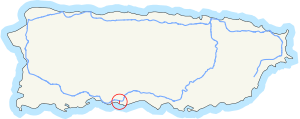
Puerto Rico Highway 12, also called Malecon Avenue,[2] and Santiago de los Caballeros Avenue, is a 5.28-kilometer,[1] limited-access highway entirely located within the city limits of Ponce, Puerto Rico, and connecting Puerto Rico Highway 14 to the La Guancha area in Barrio Playa in Ponce. It is similar to a freeway but has one traffic light near its intersection with PR-14. The highway has four exits: PR-52, PR-2, PR-133/Calle Comercio, and PR-163. Since PR-12's southern terminus is at the Port of Ponce, its traffic volume is expected to grow as construction in the new Port of the Americas is completed.[3]

References
- ^ a b Guía de Carreteras Principales, Expresos y Autopistas. (In Spanish) Puerto Rico Autoridad de Carreteras y Transportacion (ACT).
- ^ General Purpose Population Data, Census 2000. Unidad de Sistemas de Información Geográfica, Área de Tecnología de Información Gubernamental, Oficina de Gerencia y Presupuesto. Gobierno de Puerto Rico. Retrieved March 15, 2010.
- ^ Links to Port of the Americas

