
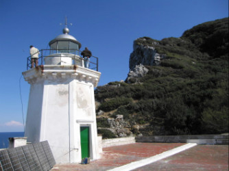
Zannone Lighthouse
 | |
| Location | Punta Varo Zannone Lazio Italy |
|---|---|
| Coordinates | 40°57′56.0″N 13°02′56.5″E / 40.965556°N 13.049028°E |
| Tower | |
| Constructed | 1884 |
| Construction | masonry tower |
| Height | 13 m (43 ft) |
| Shape | octagonal prism tower with balcony and lantern atop 1-storey keeper’s house |
| Markings | white tower, grey metalli lantern dome |
| Power source | solar power |
| Operator | Marina Militare[1][2] |
| Light | |
| First lit | 1884 |
| Focal height | 37 m (121 ft) |
| Light source | solar power |
| Range | 11 nmi (20 km; 13 mi) |
| Characteristic | Fl(3) W 10s |
| Italy no. | 2262 E.F. |
Punta Varo Lighthouse (Italian: Faro di Punta Varo) is an active lighthouse in Zannone.
See also
References
- ^ Campania an Lazio The Lighthouse Directory. University of North Carolina at Chapel Hill. Retrieved 15 December 2016
- ^ Isola di Zannone Marina Militare. Retrieved 15 December 2016
External links
- Picture of Punta Varo Lighthouse Marina Militare
This article about an Italian building or structure is a stub. You can help Wikipedia by expanding it. |
This European lighthouse-related article is a stub. You can help Wikipedia by expanding it. |