Quebrada Arenas, San Juan, Puerto Rico
Barrio of Quebrada Arenas | |
|---|---|
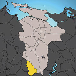
 Location of Quebrada Arenas shown in yellow. | |
| Country | |
| Territory | |
| Municipality | San Juan |
| Area | |
| • Total | 2.44 sq mi (6.32 km2) |
| • Land | 2.44 sq mi (6.32 km2) |
| • Water | 0.00 sq mi (0.00 km2) |
| Population (2000) | |
| • Total | 2,753 |
| • Density | 1,126.6/sq mi (434.98/km2) |
| 2000 census | |
Located in the southwest corner of San Juan, it is the only rural barrio in the municipality. Quebrada Arenas is totally outside San Juan's municipal urban zone according to the last Census. In 2000 it had a total population of 2,753 inhabitants, and a land area of 2.44 square miles (6.3 km2), resulting in a population density of only 1,126.6 residents per square mile (434.98 km²), the lowest for any barrio in San Juan.
The barrio of Quebrada Arenas has boundaries with the municipalities of Aguas Buenas and Caguas to the south, with Guaynabo to the west, and is bounded by the barrios of Caimito to the east and Tortugo to the north.
18°18′48″N 66°04′36″W / 18.31333°N 66.07667°W
