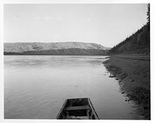
Rampart Canyon (Alaska)
Appearance

Rampart Canyon, Rampart Gorge, Lower Ramparts, and The Ramparts all are names for a high-banked canyon of the Yukon River located downstream of Rampart, Alaska and upstream of Tanana, Alaska. The canyon is located at an elevation of 226 feet (69 m) and was the considered site of a hydroelectric dam.
References
[edit]- "Rampart Gorge". Geographic Names Information System. United States Geological Survey, United States Department of the Interior. Retrieved February 17, 2009.
65°21′N 151°00′W / 65.35°N 151°W
