Rangárvallasýsla
Appearance
Rangárvallasýsla | |
|---|---|
 County Rangárvallasýsla, Iceland | |
| Country | |
| Region | Southern Region |
| Area | |
| • Total | 7,971 km2 (3,078 sq mi) |
| Time zone | UTC+0 (GMT) |
| Postcodes | 850, 851, 860, 861 |
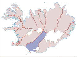
Rangárvallasýsla was a county of Iceland, located in the Southern Region of the country and the South Constituency. The county extended from the highlands, between the ice caps of Hofsjökull and Vatnajökull, to the south coast. Municipalities within Rangárvallasýsla were Rangárþing ytra, Rangárþing eystra and Ásahreppur. The main towns were Hella and Hvolsvöllur.
The county included popular tourist attractions of Skógar and Þórsmörk.
External links
Wikimedia Commons has media related to Rangárvallasýsla.
