
Rijpwetering
Rijpwetering | |
|---|---|
 | |
 The village centre (darkgreen) and the statistical district (lightgreen) of Rijpwetering in the municipality of Kaag en Braassem. | |
| Country | Netherlands |
| Province | Zuid-Holland |
| Municipality | Kaag en Braassem |
| Population | ca. 1,600 |
52°12′N 4°35′E / 52.200°N 4.583°E
Rijpwetering is a village in the Dutch province of South Holland. It is a part of the municipality of Kaag en Braassem, and lies about 8 kilometres (5.0 mi) east of Leiden.
In 2001 the village of Rijpwetering had 913 inhabitants. The built-up area of the village was 0.12 km² and contained 340 residences.[1] The larger statistical area of Rijpwetering has a population of around 1440.[2]
Famous people from Rijpwetering
- Joop Zoetemelk, Dutch cyclist and winner of the Tour de France 1980, was born in The Hague but grew up in Rijpwetering.
References
- ^ Statistics Netherlands (CBS), Bevolkingskernen in Nederland 2001 "Archived copy". Archived from the original on March 19, 2006. Retrieved January 24, 2007.
{{cite web}}: Unknown parameter|deadurl=ignored (|url-status=suggested) (help)CS1 maint: archived copy as title (link). Statistics are for the continuous built-up area. - ^ Statistics Netherlands (CBS), Gemeente Op Maat 2004: Alkemade [1].
Rijpwetering in images
-
 Rijpwetering, centre
 -
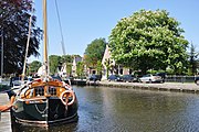 Boats in Rijpwetering
 -
 The Adermolen ('Ader mill')

.JPG)

-
 The Moppemolen ('Moppe mill')
 -
 Houses on the 'Pastoor van der Plaatstraat'
 -
 The 12-sided Lijkermolen ('Lijker mill')
 -
 Centre with church

.JPG)

.JPG)
This South Holland location article is a stub. You can help Wikipedia by expanding it. |