
Robsart, New Mexico
Robsart | |
|---|---|
 Robsart Location within the state of New Mexico  Robsart Robsart (the United States) | |
| Coordinates: 33°44′11″N 105°49′59″W / 33.73639°N 105.83306°W | |
| Country | United States |
| State | New Mexico |
| County | Lincoln |
| Time zone | UTC-7 (Mountain (MST)) |
| • Summer (DST) | UTC-6 (MDT) |
Robsart is a ghost town in Lincoln County, New Mexico, United States, which is located west of the Lincoln National Forest on Highway 54, north of the town of Carrizozo.
Robsart is served by the Southern Pacific Railway; little remains of Robsart but the Robsart Siding.[1]
Robsart may have been named by the Southern Pacific Railway after Amy Robsart from the Sir Walter Scott book Kenilworth, as Robsart, Saskatchewan received its name from the Canadian Pacific Railway.
Robsart Tank
Robsart Tank is a reservoir[2] which gets its name from the nearby unincorporated area, Robsart.
References
External links
Places adjacent to Robsart, New Mexico | |
|---|---|
Municipalities and communities of Lincoln County, New Mexico, United States | ||
|---|---|---|
| City | 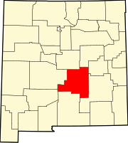 | |
| Town | ||
| Villages | ||
| CDP | ||
| Other unincorporated communities | ||
| Ghost towns | ||