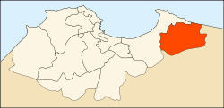
Rouïba District
Appearance
Rouïba District
دائرة رويبة | |
|---|---|
 Map of Algeria highlighting Algiers Province | |
 Map of Algiers Province highlighting Rouïba District | |
| Country | |
| Province | Algiers |
| District seat | Rouïba |
| Population (1998) | |
| • Total | 134,263 |
| Time zone | UTC+01 (CET) |
| District code | 13 |
| Municipalities | 3 |
Rouïba is a district in Algiers Province, Algeria. It was named after its capital, Rouïba.
Municipalities
The district is further divided into 3 municipalities, which is the lowest number in the province:

