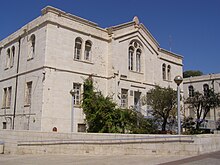
Safra Square

Safra Square (Template:Lang-he, Kikar Safra) is the site of Jerusalem's city hall. The compound was named for Jacob and Esther Safra, parents of the Lebanese-Jewish philanthropist Edmond J. Safra. Construction began in 1988 but was only completed in 1993.[1][2] Safra Square, at the eastern end of Jaffa Road, is bounded on the east by Shivtei Yisrael (Tribes of Israel) Street and forming a triangle with Tzahal Square and the walls of the Old City. Some of the historic buildings of the Russian Compound were restored and incorporated into the municipal complex.

The location of the municipality, on the seam line between West and East Jerusalem, was chosen to symbolize its goal of serving all residents of Jerusalem.[1]

History
The original Jerusalem Municipality complex was built by the British in 1930, during the British Mandatory period. As the city grew along with the need to provide more modern and diverse services to an expanding and equally diverse population, the city government's offices expanded as well, and were spread throughout the city. The decentralized municipal government decreased in efficiency, and it was decided that a single building was needed to house Jerusalem's local government. After lengthy deliberations, the current location was selected, despite the challenge of preserving the large number of historic and culturally significant 19th century buildings.[1][3]
The Canadian Jewish architect Jack Diamond and the Israeli architectural firm of Kolker, Kolker, and Epstein were selected to design a project consisting of three new buildings, to be integrated with an existing ten buildings to form a cohesive, unified site. The ten existing buildings would be preserved and rehabilitated in order to retain a sense of the historic character of the city.
The steps leading up to the complex from Jaffa Road are lined with 48 palm trees, hence the name Palm Plaza (Hebrew: רחבת דקלים). Several statues of lions, the symbol of Jerusalem, also adorn the square.[4]
Public art

At the entrance of the complex is Daniel Garden, named for Jerusalem mayor Daniel Auster. The garden contains several works of art: a sculpture based on a large, working Archimedes' screw that carries water up from a small pool, "Modern Head"; a sculpture by Roy Lichtenstein donated in memory of assassinated prime minister Yitzhak Rabin;[5] and "The Binding of Isaac" by Jerusalem sculptor Avraham Ofek.

Safra Square hosted an exhibition of the United Buddy Bears, 138 2 metre bear sculptures, each designed by a different artist.[6]
See also
References
- ^ a b c "Safra Square - City Hall". Jerusalem Municipality. Archived from the original on August 11, 2014. Retrieved August 17, 2014.
{{cite web}}: Unknown parameter|deadurl=ignored (|url-status=suggested) (help) Template:He icon says "... this area was chosen for its central location and for its accessibility to the Eastern (portion of the) city." - ^ עיריית ירושלים. Haaretz (in Hebrew). 18 May 2005. Retrieved August 17, 2014.
{{cite news}}: Unknown parameter|trans_title=ignored (|trans-title=suggested) (help) - ^ "שדחו ןשי". Jerusalem Municipality. Archived from the original on December 12, 2004. Retrieved 2007-07-24.
{{cite web}}: External link in|publisher=|deadurl=ignored (|url-status=suggested) (help) - ^ "Sister City - Jerusalem". Government of New York City. Archived from the original on October 13, 2007. Retrieved 2007-07-24.
{{cite web}}: Unknown parameter|deadurl=ignored (|url-status=suggested) (help) - ^ "Mideast Report". J weekly. Jewish Telegraphic Agency. March 28, 1997. Retrieved August 17, 2014.
- ^ "United Buddy Bears The Art of Tolerance". Retrieved August 17, 2014.
External links
- Safra Square on Jerusalem Municipality official website

