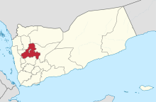
Sahar, Yemen

Sahar (سحار) is the 11th-largest city in Yemen and is in San‘a’ Governorate of Yemen.
The Sahar District has been called the food basket of Yemen.[1] It has many local markets and bazaars and a population of 133,060.[2] Sahar itself is known for the Al Talh market.
The area around Sahar has been one of the most affected areas of the conflict in the Yemeni Civil War.[1]
Climate
In Sahar, there is a cold semi-arid climate. In winter there is more rainfall than in summer. The Köppen-Geiger climate classification is BSk. The average annual temperature in Sahar is 15.4 °C (59.7 °F). About 281 mm (11.06 in) of precipitation falls annually.
| Climate data for Sahar | |||||||||||||
|---|---|---|---|---|---|---|---|---|---|---|---|---|---|
| Month | Jan | Feb | Mar | Apr | May | Jun | Jul | Aug | Sep | Oct | Nov | Dec | Year |
| Mean daily maximum °C (°F) | 21.5 (70.7) |
23.6 (74.5) |
24.9 (76.8) |
24.2 (75.6) |
25.1 (77.2) |
27.6 (81.7) |
25.6 (78.1) |
25.1 (77.2) |
24.4 (75.9) |
21.6 (70.9) |
19.6 (67.3) |
20.1 (68.2) |
23.6 (74.5) |
| Mean daily minimum °C (°F) | 2.0 (35.6) |
2.3 (36.1) |
6.1 (43.0) |
7.5 (45.5) |
9.5 (49.1) |
9.5 (49.1) |
12.5 (54.5) |
12.5 (54.5) |
9.9 (49.8) |
7.3 (45.1) |
4.6 (40.3) |
3.6 (38.5) |
7.3 (45.1) |
| Average precipitation mm (inches) | 6 (0.2) |
5 (0.2) |
16 (0.6) |
48 (1.9) |
34 (1.3) |
6 (0.2) |
55 (2.2) |
82 (3.2) |
14 (0.6) |
2 (0.1) |
8 (0.3) |
5 (0.2) |
281 (11.1) |
| Source: Climate-Data.org,Climate data | |||||||||||||
Population
- 1994 = 27,621
- 2005 = 60,487
References
- ^ a b Voices of Yemen: Sahar, Saada Governorate, from UN Development Programme 28 July 2015.
- ^ "Districts of Yemen". Statoids. Retrieved October 23, 2010.
