Salaca
Appearance
| Salaca | |
|---|---|
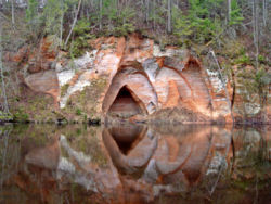
 Angels' Cave, Salaca | |
 | |
| Physical characteristics | |
| Source | |
| • location | Lake Burtnieks |
| • elevation | 42 m (138 ft) |
| Mouth | |
• location | Gulf of Riga, Baltic Sea |
| Length | 95 km (59 mi) |
| Basin size | 3,421 km2 (1,321 sq mi) (Latvia 3,239 km2 or 1,251 sq mi) |
| Discharge | |
| • average | 1.06 km3/a (34 m3/s; 1,190 cu ft/s) |
The Salaca (Template:Lang-et) is a river in northern Latvia. It flows from Lake Burtnieks in Vidzeme, 90 km, to the Gulf of Riga. The river flows through three towns, Mazsalaca, Staicele and Salacgrīva. The riverbanks feature Devonian red sandstone cliffs, and many caves and rapids as well. The Salaca is one of the best salmon rivers in all of Latvia.

External links
 Media related to Salaca at Wikimedia Commons
